The RDRC Field
![[bullet]](images/dot.gif) !!STOP!! If you don't see a menu on the left, click
HERE to jump to the front and begin your RDRC
Experience! RC Video Feeds added, check the 'Miscellaneous' section of the LH menu for these
new webcasts.
!!STOP!! If you don't see a menu on the left, click
HERE to jump to the front and begin your RDRC
Experience! RC Video Feeds added, check the 'Miscellaneous' section of the LH menu for these
new webcasts.
![[club field]](images/field1_sm.jpg)
NEW
- Live Video Feeds from
the RDRC Club Field. Look all around the field and get current weather data, live!
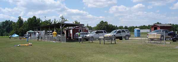
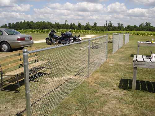
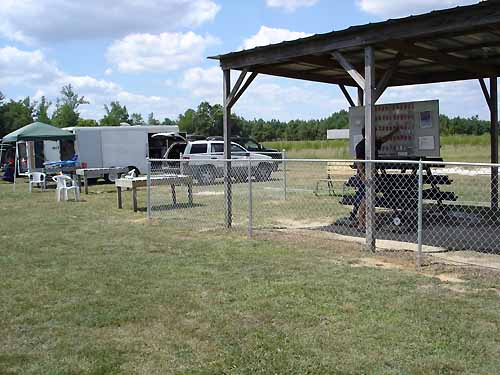
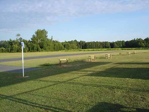
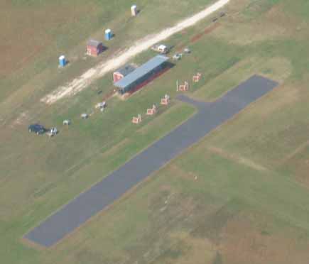
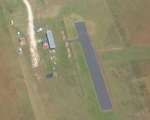
Above and below are pictures of the RDRC Field taken on 8/14/2006, just after the new fencing, gates, and
flight stations were installed. Wow, what a fresh look for the field! You can see better and
larger pictures of the area by clicking on the following links for
Picture 1,
Picture 2, and
Picture 3.
The new galvanized chain link
fencing will provide a durable safety barrier for public visitors & the parking area. There is a removable
gate for use during events, to keep pilot access to the field very simple.
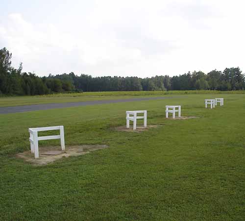
There are now 5 new flight stations in place, complete with concrete pads for the pilots standing
comfort in each station. You can also see better pictures of these by clicking on the following
links to see
Picture 1 and
Picture 2.
Constructed of salt treated timber, these stations should last for many fun-filled
years! Check out this slideshow of
PICS from the Field.
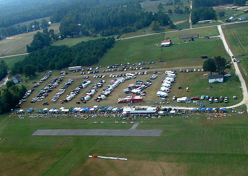
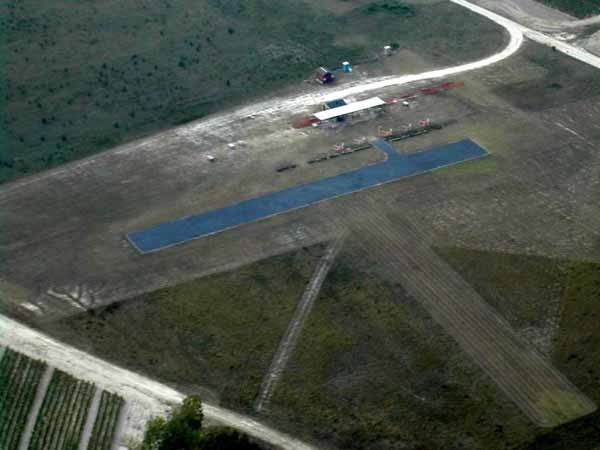
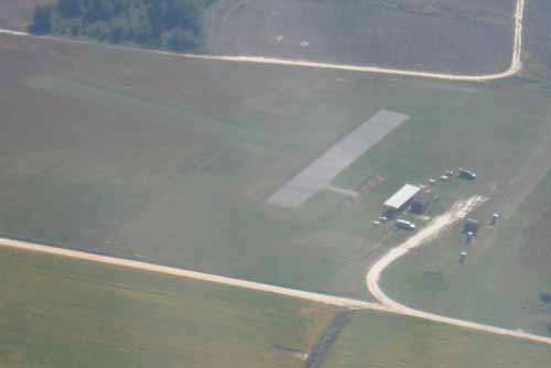
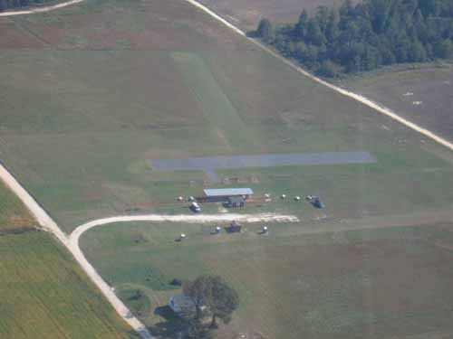
Here are several great aerial photos that have been taken and/or enhanced by RDRC
members. You'll get a birds-eye view of our paved and grass runways, parking area, shelter and
![[club field]](images/aerial1_sm.jpg) storage facilities, and beautiful expanse of flying space. By clicking on the following links, you
can view several great aerial shots, taken from several angles. Some of these were taken before our most
recent upgrades, but give a good feel for our awesome rural flying site. The first pic was
taken during our Fall Fly-For-Tots Fly-In, Sept '06. The aerial photos are
Picture 1,
Picture 2,
Picture 3,
Picture 4,
Picture 5, and
Picture 6.
storage facilities, and beautiful expanse of flying space. By clicking on the following links, you
can view several great aerial shots, taken from several angles. Some of these were taken before our most
recent upgrades, but give a good feel for our awesome rural flying site. The first pic was
taken during our Fall Fly-For-Tots Fly-In, Sept '06. The aerial photos are
Picture 1,
Picture 2,
Picture 3,
Picture 4,
Picture 5, and
Picture 6.
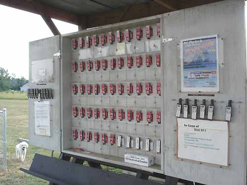
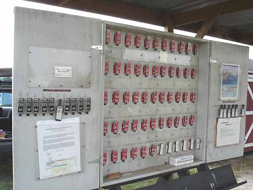
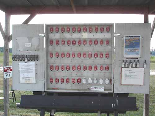
RDRC's Frequency Control Board accomodates everyone with AMA legal frequencies, from the oldest legal gear to
the new.
![[freq board]](images/board1_sm.jpg) We have frequency control pins and hangers for the legal 27 mhz frequencies, the old 53 mhz 6 meter amateur
radio (ham radio) frequencies, the new 50 mhz amateur radio frequencies, and all narrow-band 72 mhz
frequencies. By clicking on the following links, you
can view a few different shots of our frequency board. The frequency board pics are
Picture 1,
Picture 2, and
Picture 3.
We have frequency control pins and hangers for the legal 27 mhz frequencies, the old 53 mhz 6 meter amateur
radio (ham radio) frequencies, the new 50 mhz amateur radio frequencies, and all narrow-band 72 mhz
frequencies. By clicking on the following links, you
can view a few different shots of our frequency board. The frequency board pics are
Picture 1,
Picture 2, and
Picture 3.
The pic below is a satellite view of the RDRC club airstrip. Chris Hockaday photoshopped
a compass image on top of the runway image
for pilot orientation. When observing the wind speed and direction information
found on the front page of this site, on the RDRC weather page, or on eastrc.org/rdrc_live/ this may help
better understand what the prevailing winds may be at the field at that time. You can see all of
the weather data from the RDRC field by clicking
HERE, or by clicking
the [MORE WEATHER]
link found just above the weather dials on this site.
![[satellite view]](images/rdrcsat.jpg)
The Location of RDRC's SITE
![[bullet]](dot.gif) How to get to our field?? Easy!
Here's a simple, hand drawn
map to our site. You can also
get a map and directions to our site, from your front door.
How to get to our field?? Easy!
Here's a simple, hand drawn
map to our site. You can also
get a map and directions to our site, from your front door.![[bullet]](bullet2.gif) The address of AMA Club Field #733: RDRC 1339 Bethlehem Church Rd., Youngsville, NC. GPS Coordinates are: N35deg 56.459", W78deg 21.148" If coming from Raleigh on 401 north, proceed through Rolesville and past route 96 to SR-1101. Turn right on SR-1101 and continue for 3 miles to the intersection of SR-1103. Turn right onto SR-1103 and proceed for 3/4 mile. The field is on the left, and there is a large RDRC sign beside the path. If coming from towards Zebulon on hiway 96, travel approx. 8 miles north of Zebulon and turn right on Halifax road. Follow Halifax to the first stopsign. Turn left and travel approx. 100 yards to the next stopsign. Turn left on SR-1103 and travel approx. 1 mile. The RDRC club field will be on your right, and the RDRC sign will mark the entrance to the path. If coming from Wilson or the east, follow Hwy 264 west. At Zebulon, and just beyond the 264/64 merge, take 96 west and follow the instructions in the previous paragraph. If coming from Durham and Chapel Hill via Hwy 98: To get to the field from the Triangle (Raleigh, Durham, Chapel Hill) take Hwy 98 East to Wake Forest. Continue through Wake Forest. When you reach the second stop sign after Wake Forest turn right. Take your next paved left. This is State Road (SR) 1101. It actually crosses 98, but the sign is missing! Continue on SR1101 until you reach the dead end T-intersection. Turn right, and continue for almost 200 yards until you see the RDRC sign on the left side of the road. Have a look at the map page visualize our location. Click your "BACK" button to return here.
The address of AMA Club Field #733: RDRC 1339 Bethlehem Church Rd., Youngsville, NC. GPS Coordinates are: N35deg 56.459", W78deg 21.148" If coming from Raleigh on 401 north, proceed through Rolesville and past route 96 to SR-1101. Turn right on SR-1101 and continue for 3 miles to the intersection of SR-1103. Turn right onto SR-1103 and proceed for 3/4 mile. The field is on the left, and there is a large RDRC sign beside the path. If coming from towards Zebulon on hiway 96, travel approx. 8 miles north of Zebulon and turn right on Halifax road. Follow Halifax to the first stopsign. Turn left and travel approx. 100 yards to the next stopsign. Turn left on SR-1103 and travel approx. 1 mile. The RDRC club field will be on your right, and the RDRC sign will mark the entrance to the path. If coming from Wilson or the east, follow Hwy 264 west. At Zebulon, and just beyond the 264/64 merge, take 96 west and follow the instructions in the previous paragraph. If coming from Durham and Chapel Hill via Hwy 98: To get to the field from the Triangle (Raleigh, Durham, Chapel Hill) take Hwy 98 East to Wake Forest. Continue through Wake Forest. When you reach the second stop sign after Wake Forest turn right. Take your next paved left. This is State Road (SR) 1101. It actually crosses 98, but the sign is missing! Continue on SR1101 until you reach the dead end T-intersection. Turn right, and continue for almost 200 yards until you see the RDRC sign on the left side of the road. Have a look at the map page visualize our location. Click your "BACK" button to return here.
RDRC Site Map - Use the menu on the left, or
select the main entry below to go to our site's front door for best navigation.
RDRC Main Entry Point
RDRC Field Location
RDRC Contacts
RDRC Meetings
RDRC Rules
RDRC SwapShop
RDRC Pictures
RDRC Events
RDRC Application
RDRC Frequencies
RDRC Newsletters
Beginner Tips
Prop Selection Guide
Trim Guide
Fuel Facts
NC Events
Local Hobby Shops
IMAC Info
RDRC Links
General R/C Tips
Aerobatic Tips
Glow Plugs
Engine Break-In
Flat Spin
Hammerhead
Inverted Flat Spin
Immelman
Knife Edge Flight
Knife Edge Loop
Loop
Slow Roll
Snap Roll
Spin
Split-S
Wingtip Spin